SA surf outlook Feb 15 – 20 2018

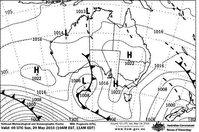
After a looooong drought the fickle Mid Coast finally scored some swell this week, but as we head into the weekend it’s fading fast. Easterly winds look set to dominate over the next 4 days at least – possibly longer.

wind

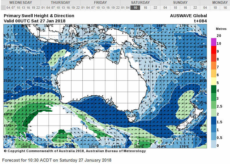
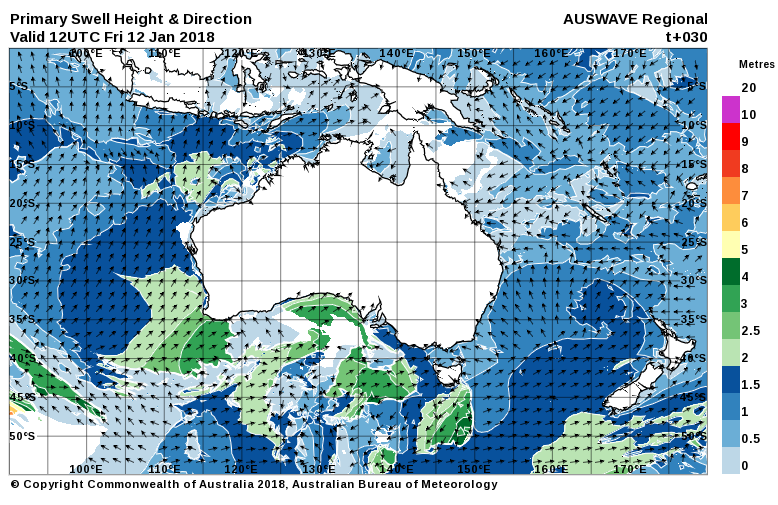
The Mid Coast is looking small tomorrow, and probably smaller Sunday, although both days should be clean with light offshore winds from the E-SE. The wind won’t be good for the South Coast with the exception of Parson’s, which will be part sheltered on Saturday. Winds look more onshore SE on Sunday, and swell will have eased a bit more. Saturday should still be in the 3 – 4′ range at Middleton – albeit a lumpy 3 – 4′.


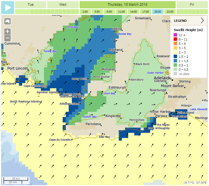
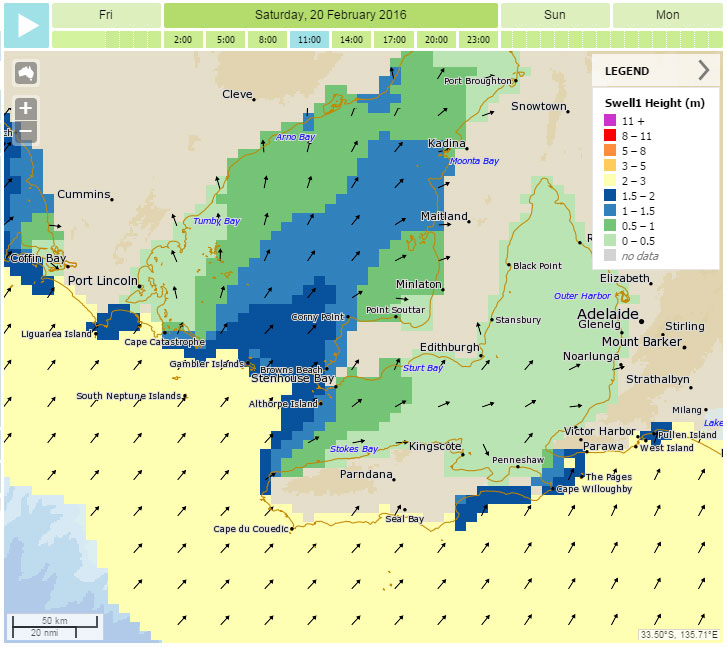
West facing breaks at Yorkes will have good winds over the weekend, Saturday will be the bigger of the two weekend days with swell continuing to wind down into early next week.

wam

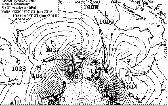
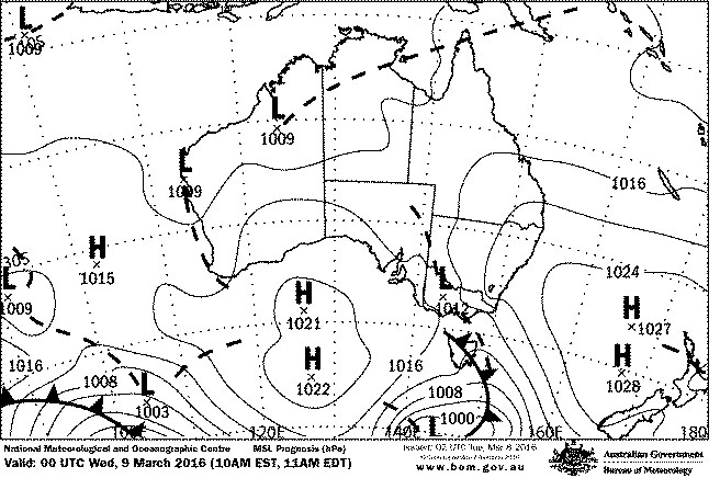
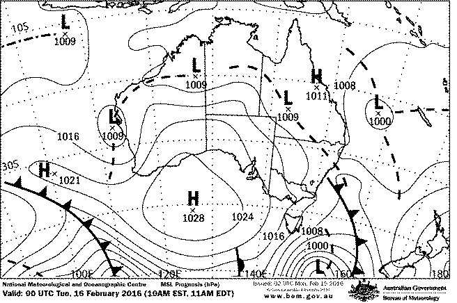
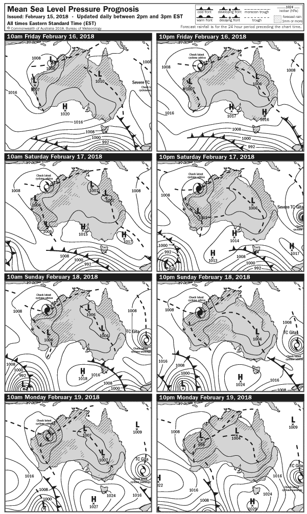
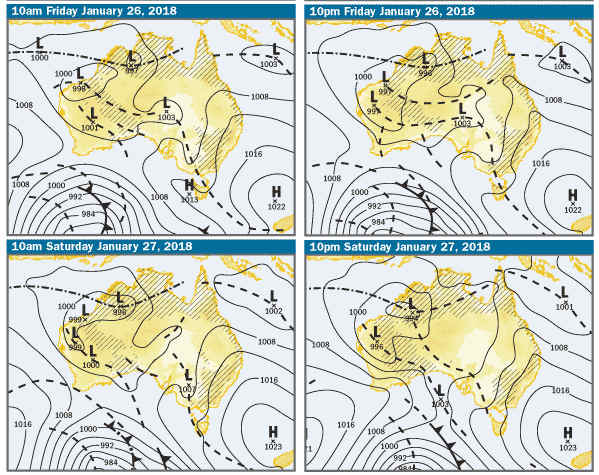
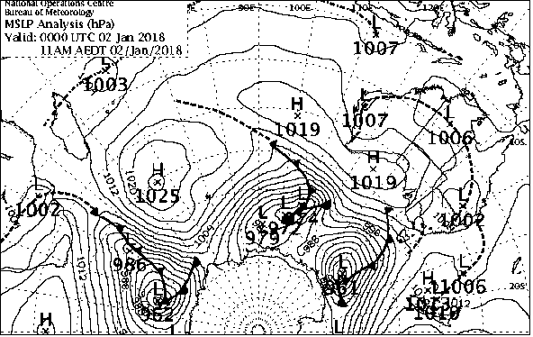
This week’s weather charts are a treat for Metnerds™ with two cyclones influencing the weather – one on the East Coast, and one off WA. While they won’t have so much effect on swell in South Oz, they will slow the passage of systems across the Indian Ocean and out into the Tasman.

charts

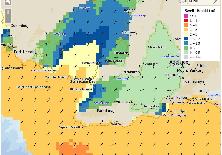
There’s also a freaky SE swell sneaking in early next week, so it will be worth a bit of exploring on the Southern Fleurieu, or even the East Coast of Eyre Peninsula.

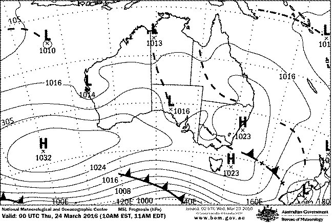
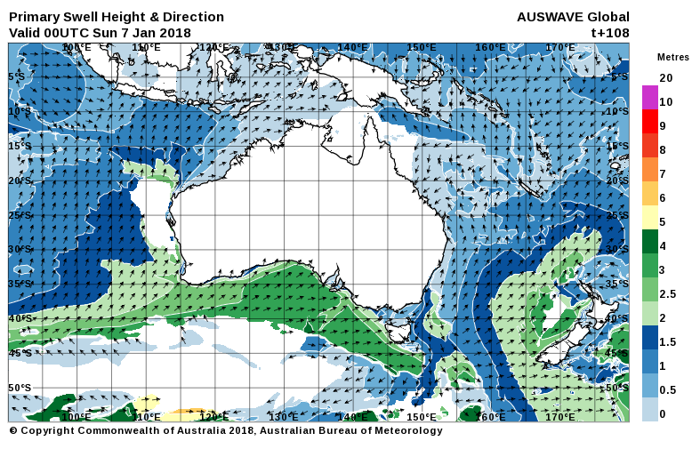
Late next week should see the cyclonic blockage ease, and some new W-SW swell.

0

SA surf outlook Jan 31 – 5 Feb 2018

We’re locked back into a typical summer sou-easterly pattern over SA this week, thanks to another big high parking itself over the bight.

chart

Much of the last week of so has seen 1′ waves on the Mid Coast, but it’s looking sketchy heading into the weekend. There may be a small blip on Thursday / Friday, but don’t expect it to top a foot. SE-E winds will keep it clean throughout, although the sou-easters will be fresh in the afternoons.

The South Coast is not going to love it, at least not until Friday when something interesting will happen. In the meantime, E-SE winds will keep things sloppy with 2 – 4′ surf Wed – Sunday at least…. possibly beyond.

The WAM chart below is for Friday, when a freaky summer phenomenon might open up some lesser known options on the Southern Fleurieu. SE swells have the ability to get around the back of KI, and a bit of a drive can turn up unexpected waves. No more clues… if you know, you know… 😉

wam

West facing breaks over at Yorkes won’t be waveless, and winds will be favourable through out for breaks anywhere between Pondalowie Bay and Berry bay. It’ll be smaller on Saturday and Sunday.

wind

Into early next week it still looks like SA will be under the influence of the blocking high, but hopefully it’ll move on and give us at least one day of NE-N winds on the South Coast mid – late next week.

0

SA surf outlook Jan 24 – 29 2018

There’s some very hot weather on the way courtesy of a very fat High pressure system in the Bight, but the Fleurieu looks a bit hit-miss heading into the Australia Day long weekend.

synoptic

Winds have been locked in an E-SE pattern over much of the week, and will only tend more Easterly on Friday, possibly NE on the South Coast early Saturday. The SW swell direction won’t be ideal for the Mid Coast, and it will continue with the same 1ft waves it’s had for the last few days.

Down South will continue lumpy with Easterly effected conditions, swell should remain in the shoulder high range and Parson’s  will favour the wind on Friday.

West facing breaks over at Yorkes will be OK for the next couple of days with light – moderate offshore winds and enough swell to keep most spots ticking over.  Swell will ease over the long weekend, Friday probably bigger than Saturday and Sunday.

wam

As we head into the weekend swell will wind down on The Fleurieu and Yorke Peninsulas, but winds will finally shift to a Northerly on Sunday. You’ll need to be on it early, with a Southerly change turning the breeze onshore around midday, and trashing conditions for the arvo. South Coast looks around the 1 – 2′ range and clean from sunrise.

wind

Heading back to work it’ll be cooler, but just to mock us it’s looking like a new WSW swell will arrive early in the week. Keep hydrated and enjoy the great beach weather in the meantime.

0

SA surf outlook Jan 11 – 15 2018

It’s literally the calm before the storm in SA tonight, with glassy seas across the state. That’ll change early Friday.

synoptic

A W-SW change will roll through during the day on Friday and the wind will start off NW and finish onshore SW on the Fleurieu and Yorke Peninsulas. The Sou-westers will persist into Saturday, but look like dropping out overnight and swinging SE on Sunday.

Swell will build over the next couple of days but quality will be messy on the Mid Coast, better down South while the wind has more west in it than south. Friday will be OK at Victor  maybe until early – mid arvo. Wind model chart is lunchtime on Saturday, which still looks pretty westerly.

wind

Sunday will be onshore down South but winds will be better for the Mid Coast and West facing breaks at Yorkes. It most likely won’t be a re-run of last Sunday, but there should be some clean waves about. WSW swell will ease during Sunday and into Monday.

wam

Heading into next week things will heat up again with new swell Tuesday-ish. More on that later…

0

SA surf outlook Jan 4 – 10 2018

Cool, overcast mornings have been the norm over the last week… but that’s about to end with a run of proper summer weather. But what about swell?

IDX0033

The next few days will be blessed or cursed, depending on your location, by an Easterly airstream. That’ll be good for Yorkes and the Mid ( but swell won’t ), but not great for Victor. There’s a bit of a window of light NE winds on Friday, but it looks like  a sou-easter might come up after lunch. Swell is on the decline over the next few days and into the weekend, until Sunday. Winds look like they will  be fresh from the North on Saturday, ahead of a westerly change sometime after lunch.

IDY30002.primSwell.108
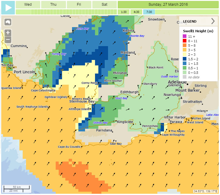
Friday and Saturday will be hot with temperatures nudging 40°C and small swell down south, nothing on the Mid and not much over at Yorkes. That should change overnight with new WSW swell building on Sunday. Winds will be onshore at Victor but  there should be enough East and swell in it for small, clean waves on the Mid. West facing breaks at Yorkes look good on Sunday too. Swell will drop a bit on Monday but winds will be similar.

The weather will be cooler on  Sunday, but looks like warming up again next week. Wind map below is for Friday lunchtime.

wind


0

A surf outlook Jun 3 – Jun 8 2016

Looking at the charts heading into next week one word pretty much sums it up… STORMY!

surface winds, 0930EST Wednesday Jun 8

There’s more cold, wet, wintry weather headed our way, and the run of light E-NE winds we’ve enjoyed ends tomorrow ( sad face ). Saturday will be a nice day on the Fleurieu with light E-NE winds and lingering swell on the Mid and South Coasts. ( 1 foot and 2 – 3′ respectively ).

Sunday will see NW winds picking up in the morning with bumpy conditions on the Mid Coast, and smaller, blown out waves on the South Coast. Winds will kick around to the West just after lunch and may be gusting over 20 knots by mid arvo. It’ll produce choppy surf in the gulf, but probably not a big stormy.

synoptic_jun5
My god… it’s full of storms!

Monday will be bigger along the Mid Coast with strong onshore WSW winds producing a stormy, South will have fresh Westerly winds and small, blown out WSW swell. Tuesday will see moderating WSW winds and bumpy conditions on the Mid and South Coast, swell direction will continue to have a lot of West so the sheltered spots down South won’t be working.

wam_6jun

Batten down the hatches on Wednesday!

The day will kick off with fresh NE winds swinging North, then NW – W at 30 knots plus. It’ll be blown out down South, and big and choppy on the Mid, and the North in the wind will probably mean stormy spots aren’t really doing it. If you can find a North facing breakwall somewhere though…

After a great week of waves last week, Yorkes will be blustery and blown out for most of Sunday – Thursday. There’s a chance sheltered spots near Marion Bay will be on a few times during the period, maybe Monday and Wednesday.

Beyond the middle of the week is pretty hard to call at this stage, I’ll update wednesday-ish once we’ve all had a good blow.


0

SA surf outlook May 27 – Jun 1 2016

Winter has definitely set in this week with plenty of rain and a cold front whipping up a stormy in the gulf this afternoon.
synoptic_may28
Over the weekend Adelaide will be sitting between two cold fronts, and conditions will quickly ease into Saturday morning, There should be semi-clean chest-high waves on the Mid Coast early with light South winds tending more SE and then ESE by late arvo. The South Coast will be onshore and messy by the looks, but should improve throughout the day with easing winds and seas.

wam_30may

Sunday is the pick of it for the South Coast with  surf in the 2 – 3′ range and light offshore NE winds from sunrise to sunset.  Monday morning will see similar winds but most likely smaller swell on the South Coast, but a possible lift in WSW swell on the Mid Coast later in the day.   Tuesday looks very similar with light NE-N winds all day.

winds_may30_2016

Yorkes looks great for the next 4 days with winds that will agree with breaks along the South Coast and the Western ( Pondie – Daly’s ) side.  Swell will be fairly solid on Saturday, smaller Sunday, then building again for the start of the week with light NE winds throughout.

Longer term a trough looks like it will cross the metro coast of SA overnight on Tuesday, with light and variable winds tending ENE on Thursday.

More on that early in the new financial year.


0

SA surf outlook Easter weekend 2016

After flirting with a more Autumn-like weather pattern this week, Easter will see a return to something more like Spring.

synoptic_23mar+24

A series of cold fronts are sweeping across the Indian ocean as we head into the long weekend, and they’ll deliver a series of good swells starting late Thursday.

These swells are all fairly SW in direction so they’ll bring good sized waves to the South Coast. The bad news is that a ridge of High pressure will extend into SA bringing predominantly onshore winds down South. Winds will be favourable for the Mid Coast, but as it’ll only get refracted swell  wave sizes probably won’t get much over one foot.

mar28_wind2

mar_27swell

Day by day it’s looking something like this:

Good Friday – building swell on Thursday should bring waves in the 4 – 5′ range at Middleton early. Onshore SE winds will get up around 15 knots during the day and make a mess of it. The Mid Coast might get to 1′ or so, and should be bigger than Thursday. West facing breaks at Yorkes look good all day, ranging 3 – 5′.

Easter Saturday – A second SW swell will keep the swell pulsing down South, and with winds tending more SW a few sheltered spots like The Dump or possibly Chicken Run may come into play. Light winds and 1′ waves on the Mid early look like picking up and adding bumps later. Selected spots at Yorkes will be a good size early ( 3 – 5′ ) but most will probably become wind effected during the course of the day.

Easter Sunday – a third pulse in SW swell should lift size to around the 6′ mark at Middleton, and 6’+ out the other side of Victor. 10knt SE winds will pick up to 20 knots later, so it’ll most likely be a mess down there. The Mid Coast again will get some refracted swell and possibly 1 – 2′ waves at magical points in the tide. Some SW facing breaks at Yorkes may be in the 6′ range and winds will be best in the morning.

Easter Monday – Winds should ease overnight and become light early, opening up a possible window on the South Coast. It’ll deteriorate with onshores during the day, if the wind maintains enough West in it sheltered spots could be good early. Surf should be around 5′ at Middleton, 1′ on the Mid and becoming bumpy after lunch. Again, Yorkes will be good early and Monday is probably the best shot for semi-clean and solid waves at Chi’s, with winds picking up and quality deteriorating during the day.

If anything major changes I’ll do a mid- Easter update.

0

SA surf outlook Mar 8 – 12 2016

A 4m SW swell is delivering reasonable waves to the South Coast today with light winds, and some of it has even managed to refract into the gulf. It will fade overnight, but a similar swell will top up waves heights again late on Thursday.

mar11_wind

In the meantime the tropical weather is set to continue with another large, slow moving binary high pressure system drifting over the Bight. Winds will stay out of the SE-S over the Fleurieu, and swell will ease through Wednesday and initially be small on Thursday. The southerly airstream will keep the South Coast lumpy all week, but Friday morning may provide  a window with very light winds and a good SW swell peaking overnight, leaving reasonably clean 4’+ waves along the Day St stretch.

synoptic_8mar+24

Yorkes will be up and down, but SW facing breaks will have good winds and waves in the 1 – 3′ range over the next few days ( best Wed and Friday ).

The Mid Coast probably won’t top 1′ for the rest of the  week, early Wednesday high tide reefs will have some Mally waves, Friday will probably be similar and glassy early.

mar10_swell

Heading into the long weekend swell initially will be small with S-SE winds, so Saturday looks onshore at Victor and almost flat on the Mid Coast. There’s some hope though, with a new WSW swell brewing and hopefully some clean 1 – 2′ waves on the Mid Coast Sunday – Monday. More on that toward the end of the week.

0

SA surf outlook Feb 19 – Feb 23 2016

A SW swell peaked on the South Coast today but didn’t have enough west in it for the Mid Coast, however we should see a small lift in WSW swell overnight tonight.

feb23_wind

The weekend will kick off with light ESE winds and waves back up to around 1′ on the Mid Coast, but the South Coast will be lumpy with SE winds on Saturday. The days that follow will see a gradual “Northerning”  of winds and improving conditions down South, with clean waves and light offshores prevailing almost all of Tuesday. Surf will be around 3 – 4′ down South over the weekend, fading into Sunday with light East winds ( possibly NE early ) tending light W-SW later in the day. The Mid Coast probably won’t top a foot all weekend, Sunday will be smaller than Saturday by the looks.

synoptic_19feb+24

West facing breaks over at Yorkes will have good winds throughout, and surf ranging 1 – 3′ over the next three days. Tuesday morning should benefit from a small, building SW swell on Monday night. Chi’s should have more favourable conditions on Tuesday.

feb19_swell

Mid week some new swell should push in, a SW swell for Victor ( Monday – Tuesday ) and a WSW swell that will hopefully lift the Mid Coast over 1′  ( Wednesday / Thursday ). Winds will turn onshore down South mid week, but at this stage SE – E on the Mid Coast toward the end of the week.  Next update will be Tuesday-ish.

0