SA surf outlook May 24

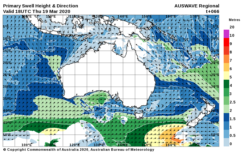
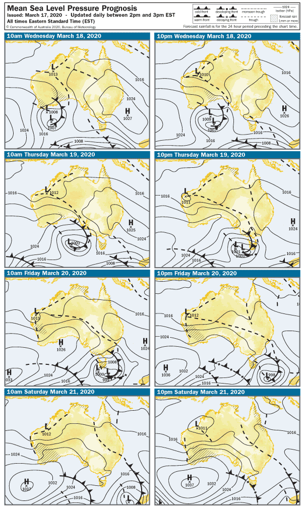
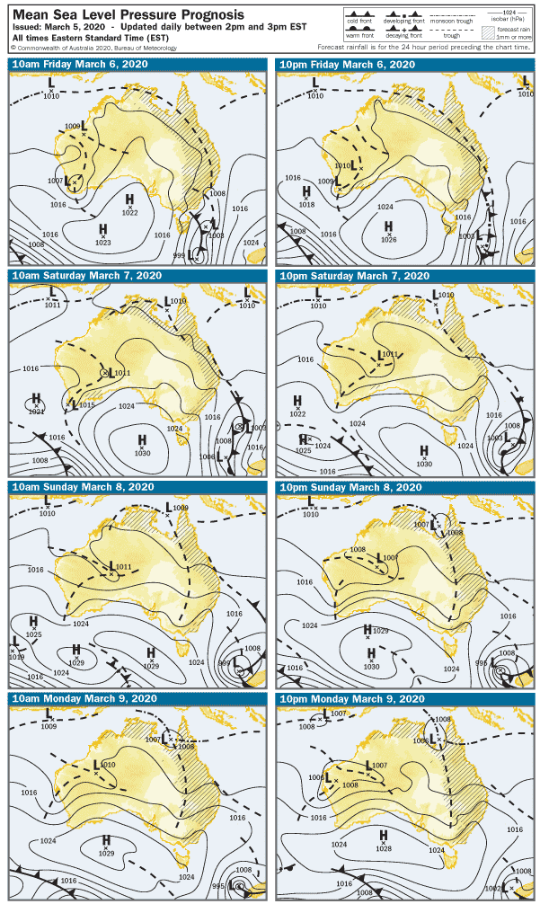
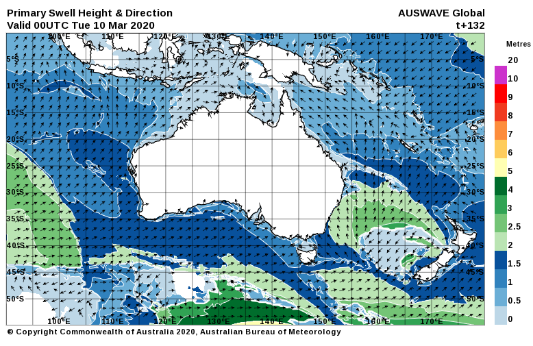
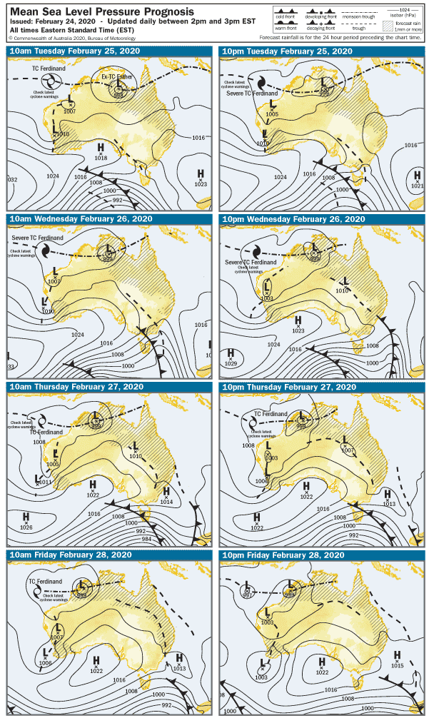
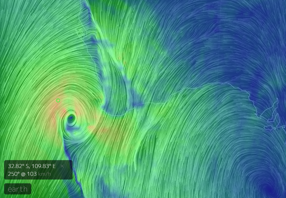
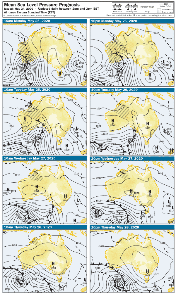
I know it’s not SA, but take a look at this beast that’s about to slam the West this evening. It’s the remains of ex-TC Mangga bumping into old mate Cold Front and Trough, and the three of them kicking off an evening sucking lemons and slamming Tequila shots. Needless to say, there are all sorts of warnings out, and seas will be huge. That wind is gonna do some damage when it slams into SW WA this evening, so let’s hope our COVID-free brothers and sisters stay safe tonight.

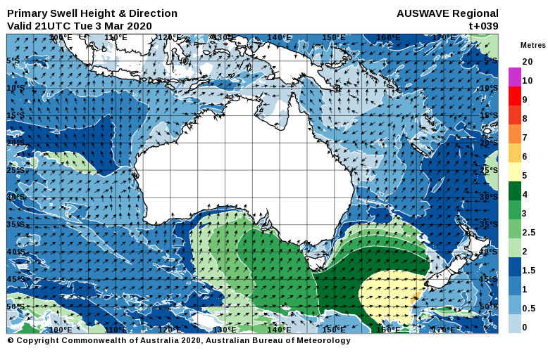
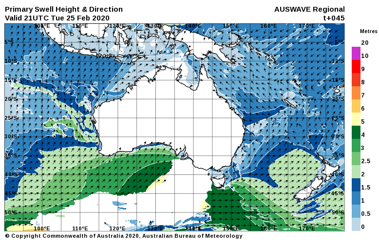
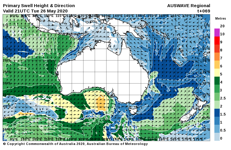
Meanwhile… all is calm in Southoz, but we have a pretty interesting looking week ahead with a particularly good looking westerly swell on the way.

Light South winds have all but dropped out over the Fleurieu and Yorke peninsulas this evening, and early on Monday morning the breeze will be just a puff from the East.  The Mid Coast will continue its recent lameness and waves will struggle to top shin high. It’ll be glass early at least. The easing swell will leave waves around 2 – 3′ at Middleton, and the light East winds may add some lumps. And more brown crap.

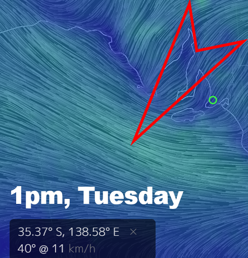
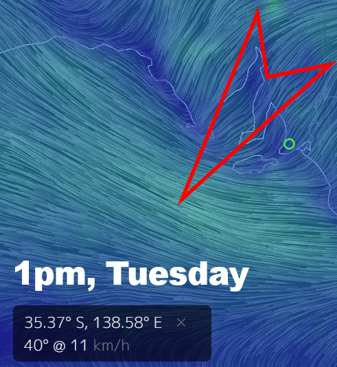
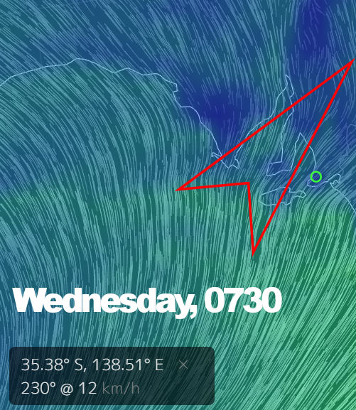
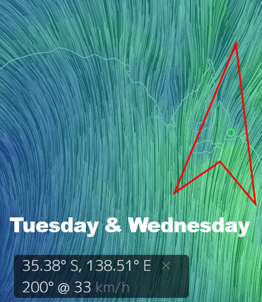
A light Northerly will kick off Tuesday morning and conditions will be nice and clean on the South Coast. The swell will be smaller though, and Middleton is looking around 1 – 2′ all day.  Wave heights on the Mid Coast will lift to 1′ or so, but the North wind will add lumps.
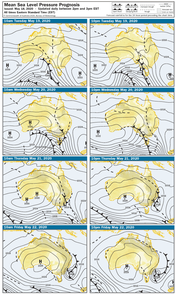
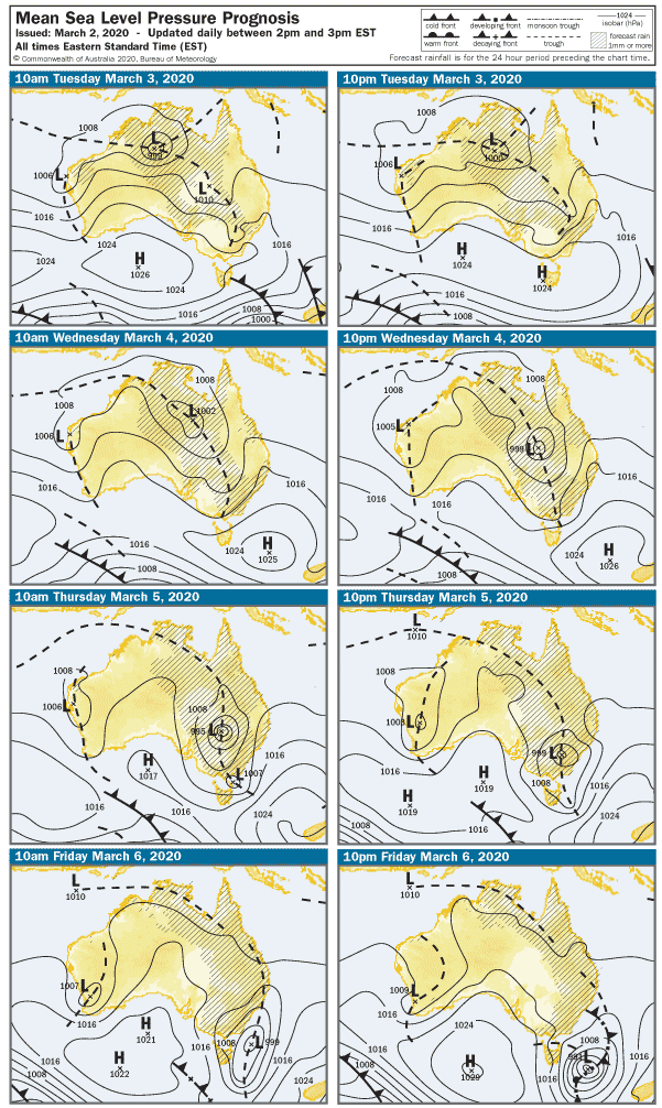
Which brings us to Wednesday

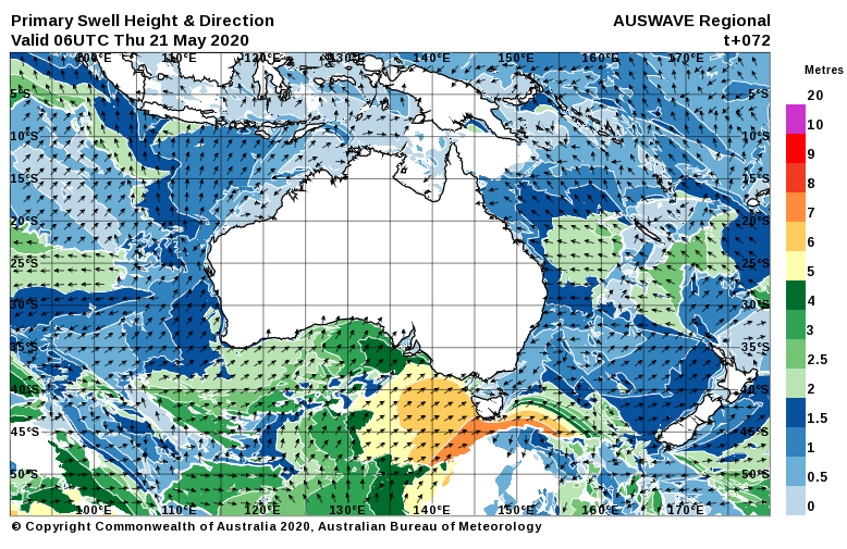
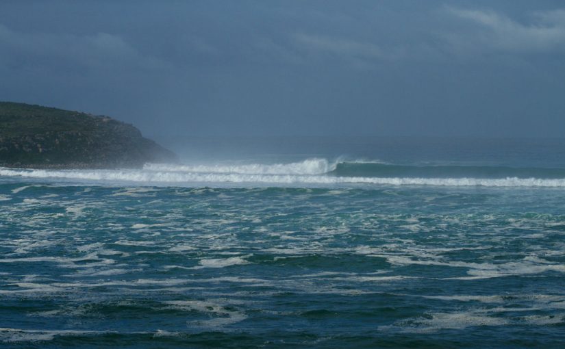
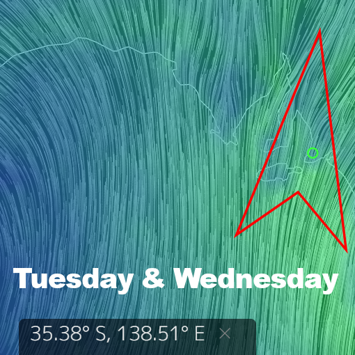
A WNW wind around 12 knots will add a few bumps on the Mid Coast and over at Yorkes, but west-facing breaks will get their first whiff of a brand new swell. It’s about as westerly as it gets, so there’ll be some solid waves later in the day along exposed, sunset-facing coastline. The Mid Coast will kick off around 2′ and may have a few lumps, but the wind will drop to nothing by mid arvo. Better still, the incoming tide will bring a building swell with it, and 3′ sets look possible. The tide will be a bit full after 4pm, but there should be waves everywhere. The swell will mostly miss the South Coast, and it may even be one of those crazy days when the Mid is actually bigger. West facing breaks over at Yorkes mid arvo FTW.

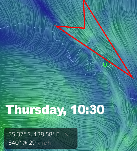
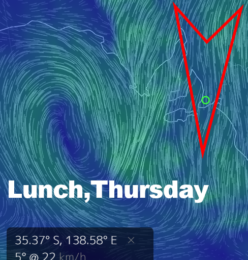
Thursday looks damn good as well. There will be bugger all wind all day ( if the models remain true for the next 4 days, reasonable chance with  a large HIGH moving across SA ) and the Mid Coast will have clean 2′ waves. West facing breaks over at Yorkes will be excellent all day, and at least some of the swell should wrap in along the South Coast. Middleton may get up around 3 – 4′ later, and it’ll probably be glassy all day.

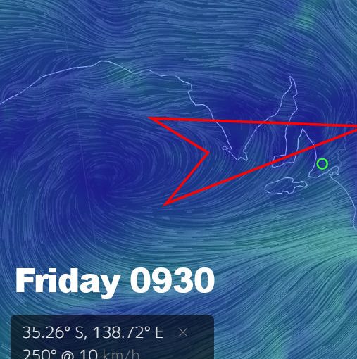
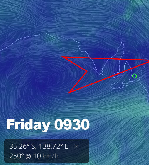
We’ll go back to a Northerly on Friday morning as another front approaches SA.  the Mid Coast will remain in the 2′ range, but it’ll be bumpy with 15 knot winds blowing down the gulf. The South Coast will be clean, and surf may be in the 3 – 4′ range at Middleton despite a less-than-perfect swell direction.

The weekend looks like it’ll coincide with a cold front and WNW winds on Saturday at 20 knots or more. The Mid Coast will maintain 2′ waves but quality doesn’t look great, the South Coast should be clean but possibly blown out along exposed stretches.  It’s a bit hard to call after Sunday, but I’ll slip an updated forecast in later this week to cover that.

For now, get amongst it – the water ain’t too cold yet and there’ll be plenty of opportunities across the state this week


0

SA surf outlook May 18

The eagle-eyed among you might have noticed that South Australia’s longest-running and most reliable surf report quietly returned to business a couple of weeks ago.  Some degree of sanity seems to have returned to coastal areas from mid-May onward, and as water temperatures drop in coming weeks that will hopefully continue.

The height of the pandemic offered some great waves in SA, and those in the more remote parts of the state scored amidst travel restrictions. With barely 2 weeks of Autumn left, there looks like a few opportunities to nab some decent waves before we all are forced to break out the heavy rubber, hoods, and booties.

A few cold fronts and troughs will roll across southoz this week, and today probably marks the end of a run of the warm, fine weather.

Early Tuesday will open to 20 knot NNW winds, and the breeze will pick up ahead of a cold front and Westerly change after lunch. Middleton will be clean but exposed stretches will be blown out not long after sunrise with surf around 2′ building 2 – 3′ later. The lingering swell on the Mid Coast will get a top-up but it’ll be bumpy in the morning with the wind. Surf will be around 2′, but it’ll build to a medium sized stormy after lunch with onshore Westerly winds around 27 knots. Part sheltered spots may get a look-in after 3pm.

A second front ( and trough ) will whip the coast around lunchtime on Wednesday, winds will be WNW at 22 knots in the morning shifting onshore Westerly at 27 knots after lunch.  The Mid Coast looks around 1 – 2′ and bumpy in the morning, with another medium-sized stormy building after lunch. Middleton will be blown out and 2 – 3′ in the morning, picking up 3 – 4′ later as the swell kicks in.  The Bay will be worth a look later, and possibly even The Dump late arvo.

The wind will go more Southerly overnight and early Thursday it’ll be back to 10 knots from the SSW. The Mid Coast will be bumpy but possibly glass with leftover 2′ waves. The dead onshore wind will be less favourable for the South Coast, which is a shame because a new SW-S swell should lift waves heights into the 5 – 6′ range by late arvo. Everywhere will be bumpy. West facing breaks over at Yorkes will have decent swell, but you’ll need to pick somewhere a bit away from the South wind.

Friday is your day for the South Coast.

The wind will be cross-onshore so not quite perfect, but at 5 knots in the morning it should be reasonably clean early. The swell looks solid too – the Chiton – Knight’s stretch is looking in the 5 – 6′ range, and even the dear old dump should have some decent sized, clean waves.  The swell is looking bigger in the morning and backing off by a foot or so after lunch. The wind will tend more SW after 1pm, but it shouldn’t be much over 10 knots all day. The Mid Coast will be lumpy / glassy with surf around 1 – 2′.

Heading into the weekend winds will be more favorable for the Mid Coast and west-facing breaks over at Yorkes. Saturday should open to a moderate SE wind and fading swell, with surf around 1′ on the Mid Coast. The onshores will leave plenty of lumps on the South Coast, with Middleton in the 3 – 4′ range.

On Sunday the breeze will be almost dead East in the morning, so the Mid Coast should be smooth – but waves will only be around 1′. Surf will be lumpy and around 3′ from Middleton to Goolwa, Parson’s will be the pick of it for more expert / fitter surfers.

Gazing into the crystal ball, a new WSW swell will begin to push in at the start of the week, and it could be pretty good along west-facing coasts Tuesday / Wednesday. Winds are too hard to call for now, so check back for an update later in the week.


0

Surfsouthoz response to the Covid-19 pandemic

March 29, 2020.

I’m writing tonight to tell you about a few changes you’ll notice with surfsouthoz, starting on Tuesday March 31.

Firstly, the surf forecast which returned to bi-weekly in February this year, will be paused. The last three forecasts have also been deleted. Secondly, the daily surf reports for the Mid Coast and South Coast will be paused. There will be no surf report or surf forecast related content posted on surfsouthoz.com.au after tomorrow, March 30.

At this stage, the pause will be for the month of April and March 31 2020, but the end date may be extended.

I have ruminated a lot on this over the last few days, but recent events have pushed surfsouthoz in this direction. The CoVid -19 pandemic has changed everything. Those on the front line of health care in Australia are already under massive stress and in constant fear as the situation deteriorates. But meanwhile, far too many people are carrying on as if nothing is happening and everything is great. News of car parks on the South Coast overflowing on Saturday, and campsites on the Eyre Peninsula filled to the brim last week, were to say the least, disappointing. Victor Harbor recently topped the list of CoVid-19 vulnerable areas nationally, due to its large and aging population.

In all conscience, surfsouthoz cannot, and will not, contribute to jeopardizing the safety of those vulnerable people. The same goes for the Yorke Peninsula and Far West Coast community who have limited access to critical medical services. If you choose to still visit those areas, that’s up to you. From now on the message from surfsouthoz can’t be mixed or ambiguous. The message is this: Don’t go surfing. STAY AT HOME.

But let me take this moment to say thanks for all the likes, the comments, the funny shit you post on social media, and the emails… even the ones telling me to lift my game or to just shut the fuck up. Thanks to everyone I’ve got to know over the years purely because I keep turning up and doing this shit day in, day out. You guys and girls have made the coast more than just a place to live for me. You’ve made it my home.

Surfsouthoz has been South Australia’s longest running daily surf report, and this April would have marked its 20th year. 2020 is going to be a very tough year for all of us, and many challenges lie ahead. But once this dark time has passed, surfsouthoz, and many other creative people, businesses, and services, will be back.

Take care, and look after those you love. We’ll get through this together.

– Pete Mariner aka dUg / boyd kalimba / the surfsouthoz guy

0

SA surf outlook Mar 17

Well, here we are in a post COVID-19 world where even bloody Leprechauns are running for cover and there’s not a green beer in sight because pubs are closing up everywhere.  Meanwhile, There’s talk in workplaces of “self-isolation”, and doing so might even be seen as virtuous. With that mind, why not just call in to work tomorrow, then load up the car and find some far-flung empty reef break 8 hours away? You won’t get much more self-isolated than that. You should do it for the greater good.  Go on.

As we go to (word) press, seas are smoooooth and glassy across two of SA’s bestest peninsulas – but swell is sadly lacking You had better brace yourself for more of the same in the short term.

SA is still in a bit of a transitional weather pattern where it’s neither summer nor autumn, so we have troughs and LOWs at high latitudes and not many strong, SW swell generating weather systems at lower latitudes. It will change after Easter, but for now it looks like  Northerly winds and small swell for the next couple of days.

On Wednesday winds will be light from the North early, picking up through the middle of the day and tending NW, then glassing off again mid arvo.  The Mid Coast will be flat again early, but might build to shin-high off low tide after 3pm.  The swell will remain small down South, and Middleton will only have waves around 1′.

The breeze will tend more NW on Thursday, 15 knots early but getting up over 25 knots through the middle of the day before shifting to the West and easing.   The Mid Coast will be dead flat, and your only hope on the South Coast will be Waitpinga at around 1′.

A SW change will roll through early Friday morning, and the Mid Coast will score some long-awaited new swell, Unfortunately, quality is not looking great with SW wind at 17 knots in the morning. The breeze should swing almost dead South by evening, which might be OK at the southern end of South Port.  The new swell won’t be great for the South Coast, but Middleton should build from around 1′ in the morning to 2′ after lunch. Quality is looking bad for the arvo with onshores in the 17 knot range.

The swell will be winding down heading into the weekend, but the Mid Coast might still manage some rare 1 – 2′ sets in the morning on Saturday. Winds will be SE at 10 knots, so it’ll be clean. New swell will be hitting the South Coast and Middleton should be around 4′, but it’ll be lumpy / messy with the dreaded sou-easters into it.

The swell will be solid on the South Coast early Sunday with waves around 5′, but quality will be poor again with SE winds at 10 knots picking up after lunch.  The Mid Coast will be clean, but waves will only be around 1′.

Heading into next week, winds will be Easterly on Monday morning and surf should still be in the 4- 5′ range at Middleton – just lumpy. The Mid Coast will be clean, but waves will only be around 1′. SW facing breaks over at Yorkes could be good over the weekend.

The middle of next week looks like it might fall in a bit of a hole swellwise, but it’s still a long way off.  Hopefully the situation changes for the better between now and then.

0

SA surf outlook Mar 13

Monday’s forecast was not far off the money, and the South Coast did score offshore winds on Thursday as expected.  Unfortunately the swell was now quite as co-operative, and Middleton was around 2′ in the morning and faded to an inconsistent 1′ after lunch. There was a glass off over the Fleurieu ( also predicted 🙂 ) mid arvo, and the tiny lines of SW swell attracted at least 20 SUP’s to U-turn’s.  The change rolled through this morning as expected, and it’s not looking great with 20 knot SSE winds and 1′ waves on the Mid and slops down South.

Another large HIGH will roll in over the weekend and the wind will be mostly Easterly, and fresh from the SE in the afternoons.  The Mid Coast will be 1′ on both Saturday and Sunday, clean early but possibly a bit blown out with ESE winds in the 17 knot range. The swell will peak overnight on the South Coast, but it should still be serving waves in the 4 – 5′ range at Middleton early Saturday.  Quality will be dreadful with cross-shore ESE winds at 10  -15 knots, shifting SE later.  West facing breaks over ta Yorkes won’t be big, but should have clean waves in the 2 – 3′ range over the weekend.

On Monday the breeze should drop under 10 knots in the morning, tending more ENE. The Mid Coast will be clean but waves will only be around half a foot, west-facing breaks over at Yorkes will do better. The South Coast is worth a punt on Monday with winds shifting North after lunch at around 10 knots and waves in the 2 – 3′ range at Middleton. There’s bound to be some leftover wobbles from a few days of E-SE winds, but it’s probably the best looking day in the forecast period.

The swell will wind down overnight and wave heights will be back to 1 – 2′ at Middleton on Tuesday. It’ll be clean but a bit blown out in the morning with winds possibly over 20 knots from the North. It looks similar to Thursday, with winds dropping out after lunch but swell fading with it. The Mid Coast will be bumpy early, glassing of later but waves will only be around half a foot.

A change is headed for SA on Wednesday, and should arrive between 2 and 4pm. Ahead of the change the wind will be fresh from the NW at 22 knots, shifting Westerly after lunch. The Mid Coast will be choppy and only half a foot early, but will probably build to around 2′ with fresh onshore winds late arvo.  Middleton will be around 1′ and mostly blown out all day.

The change should leave a stormy behind on the Mid Coast on Thursday, and it may get to 3′ in the morning with 27 knot W-SW winds. Conditions will moderate after lunch and stormy venues look marginal. Surf will be semi-clean if slightly blown out on the South Coast, with waves around 1 – 2′ at Middleton. The swell will kick a bit after lunch but quality probably will not.

The swell will have a lot of West in it, and there’s chance it might just roll into Friday morning with easing winds. More on that in the next forecast.

0

SA surf outlook Mar 9

It’s definitely a case of mixed feelings when it comes to last week’s forecast. The long weekend panned out almost exactly as expected, and that was almost entirely crap. This evening the Mid Coast is clean and continuing to look more like a lake than a surfing reserve, and the South Coast has 2′ of slops for the 8th day straight.

But put away the sharp objects for the time being – things are looking better mid-late week.

The latest 4-day synoptic still shows loads of those pesky troughs, but you should note the large high over Tassie. It means that sucker is headed east and out of our lives.

Not a lot will change early on Tuesday  the wind will be lighter form the East and possibly become light and variable after lunch. The Mid Coast will be flat again in the morning on the high tide, but don’t be surprised to see a few small lines mid – late arvo as the tide pushes back in. It probably won’t reach knee-high but at least it will be an improvement over the last 2 weeks. On the South Coast expect lumpy conditions, becoming lumpy / glassy after lunch with little or no wind. Middleton will be in the 2 – 3′ range.

On Wednesday we’ll finally get to see the wind swing offshore on the South Coast. The breeze will be NE at 7 knots in the morning, but should be dead offshore from the North at 10 knots after lunch. It won’t hurt to give it a few hours to straighten up, after lunch waves should be semi-clean and 2′ at Middleton – building toward late arvo. The Mid Coast will be clean all day, with 1′ waves.

Thursday also looks like it’ll be graced with offshores on the South Coast, and Middleton should be clean in the 2 – 3′ range. This is looking like the best day of the week to hit the South Coast.  The Northerlies will add bumps on the Mid Coast after lunch, with surf around 1′ all day. There may be a Mally wave early with light N-NE winds. Southern coastline over at Yorkes ( e.g. inside Innes NP ) looks pretty good on Wednesday and Thursday.

A weak front will roll through early Friday, turning winds to the WSW. At the moment it looks very light early, maybe 5 knots or so over the Fleruieu. A new WSW swell looks like lifting wave heights to 1 – 2′ on the Mid Coast, but a fresh Southerly wind will fill in later and add bumps along exposed stretches. A building swell will lift Milddeton to 4′ or so after lunch, but quality looks awful.

The weekend looks alright for a dash to Yorkes ( much better than the long weekend was ), winds will be out of the East – ESE both days, in the 15 knot range. West facing breaks will be clean and most of the usual suspects will have waves. The Mid Coast should have some 1 – 2′ leftovers on Saturday, fading to 1′ on Sunday. It’ll be clean all weekend. The South Coast won’t do as well, although there’ll be plenty of swell on Saturday. Middleton may be in the 5′ range, but with 10 – 15 knot East winds it’ll be pretty nasty. A few lesser-known spots to the West may be worth a  look though. Sunday will see the swell drop by a foot or so, and East winds continuing from Goolwa to Parson’s.

A new WSW swell is lining up early next week, but we’ll circle back on that Friday-ish.

0

SA surf outlook Mar 6

I’m calling this the “Home and Away” forecast, because if you’re reading this it means you are either:

a) not going away on the long weekend, and looking for whatever scraps you can get within 70km of the Adelaide GPO

b) going somewhere outside SA and looking for some positive reinforcement that you made a good call ( spoiler alert… you did ).

Here’s the latest synoptic chart, just in case you are interested in such things.

There’s a lot of rain over the East coast and troughs all over the country, but all we really care about is that fat HIGH that’s parked its arse SW of Adelaide. That sucker will dominate the weather over the long weekend, and as far as surf goes, it won’t be dominating in the “awesome” way.

At least we’ll escape the dreaded Southerly winds early on Saturday as the wind kicks around to the ESE.  The Mid Coast will be clean, but dead flat. West facing breaks over at Yorkes also look pretty sad, Pondie might manage 1′ waves if you’re lucky. The last few days will leave the South Coast pretty messy, and early Saturday it’ll be lumpy and thanks to a fading swell, around 2′ at Middleton.

Sunday is not looking epic either with The Easterly airstream continuing. The swell will miss the Mid Coast for the 64th time this year, but it’ll be nice and clean. West facing Yorkes breaks will mostly suck, and the South Coast will be lumpy with the shitty wind. Middleton is looking like remaining in the 2′ range.

The last opportunity for long weekend glory, Monday, doesn’t look a whole lot better. The wind will still be from the East at 10 – 15 knots almost all day, the Mid Coast will still be flat and Middleton will only be around 1 – 2′. Yorkes will finish the weekend in similarly poor form to which it started.

Just to throw a curveball, you’re probably better off heading South-East of Adelaide over the long weekend, especially if you’re still in a funk about what to do to find waves. Robe – Beachport ( and beyond ) have done better over the last few days than much of the rest of the state, so it’s worth rolling the dice with petrol under $1.20 a litre. Worst case… just drive another 4 hours to the Surf Coast.

As if to mock us, Tuesday morning will offer SA the first whiff of North in the wind. The lumps will persist on the South Coast thanks to days and days of Easterlies, but a Nor-easter after lunch will do its best to straighten it up. The swell will come in a bit more westerly so expect only around 1 – 2′ surf at Middleton, but Parson’s will be a bit bigger and nice and clean for much of the day. The Mid will finally see a glimpse of new swell, waves might even get to a foot by sunset. West-facing breaks over at Yorkes will be OK after lunch.

We’ll finally see Northerly winds on Wednesday, so grab it because it might be your only chance this week. The West in the swell will persist and cap size  a bit on the South Coast, but there still could be some clean 2 – 3′ waves after lunch. This is probably the best day in the period to hit Yorkes. Even the fickle Mid Coast might score a few waist-high waves, and better tides will hopefully give it a push.

On Thursday the wind will probably be back to the SE so the South Coast will be over, but west-facing breaks over at Yorkes should be good and the Mid Coast might manage a few 1 – 2′ waves.

Looking ahead, a good WSW swell appears to be lining up heading into next weekend – but let’s see how that pans out after the horse race no-one will go to.

0

SA surf outlook Mar 2

Summer 2020 ended with a great run of South swell in Southoz, delivering pumping waves to South facing coast over the last 4 days. The same swell hit the Surf Coast in Vicco today, and Bells and Winki scored the swell of the year so far, with beautiful glassy conditions.

The swell pulsed twice on The Fleurieu, and that was pretty much as predicted in the last forecast. SA’s cool kids scored fairly clean 6 – 8′ Bullies on Friday, but a surge in the swell Sunday arvo conicided with the wind dropping out allowing a dedicated few to score some very nice waves indeed. Meanwhile, back on the Mid Coast, it’s still shit. Five weeks of shit and counting…

For the rest of this week, SA will slip into a Southerly airstream, and it looks like holding right up to and thorough the long weekend.

On Tuesday, the Mid Coast will be lucky to see a few 1′ waves in the morning. It’ll be clean with light-moderate SE winds. The swell will fade overnight on the South Coast, and it’ll be lumpy with SE winds in the 15 knot range all day. Surf will be around 3 – 4′ at Middleton. West facing breaks over at Yorkes will be clean for most of the day, and those spots that wrap in Southerly swells will be worth a look. Even Pondie should still be fun.

A new Southerly swell will fill in on Wednesday, but it’ll come with Southerly winds. Early the breeze will be light, so there is a chance of scoring on the South Coast. Surf should build to around 5′ at Middleton, so again the Victor – Port Elliot stretch may be the go with a swell direction and size similar to Friday. The Southern coast of Yorkes will be onshore, but selected west-facing breaks will wrap in some of the swell. The Mid might manage 1′ waves, but with a refracted swell it’ll be more gutless than usual.

On Thursday the wind will be light again early, but onshore from the South all day. Surf will be in the 3 – 4′ range at Middleton, easing after lunch. It’ll be lumpy all day with the onshore wind. The Mid Coast will only be shin high, clean early, and bumpy after lunch.

The swell will ease further into Friday, the Mid Coast will be flat with light ESE winds and Middleton will be lumpy and in the 2′ range. West facing breaks ver at Yorkes will be clean, but marginal size-wise.

The Mid Coast flatness will continue over the weekend, and it’ll be lucky to top shin-high on Saturday or Sunday.  Seas in the gulf will be smooth with E-SE winds, and mostly flat.

The South Coast will be onshore all weekend and surf will only be around 1 – 2′ at Middleton on Saturday. Sunday arvo should see a new swell start to push in, and it may get to 2 – 3′ after lunch.  Winds are looking light – moderate Easterly at this stage, so there will be lumps. The long weekend is not looking epic.

Early next week a new WSW swell is lining up, but it’s a long way off and anything… or nothing… could happen in between.

0

SA surf outlook Feb 24

I’m not gonna lie… I expected to see a few small lines hitting the Mid Coast at daybreak today, but 13 hours later I’m typing this and staring at nada surf. It’s not even a foot on the reefs, but there are signs of life on the South Coast this afternoon with a new, well defined SW swell starting to push in. It’s onshore down there, of course…

The week ahead looks like another one of mild weather, and it looks like Summer 2020 will go out with a whimper rather than a bang.  Swellwise though, it’s looking very interesting with two pretty solid SW swells lining up this week. Also a bonus cyclone off Pt Hedland which will feed in moisture later in the period.

The swell will lift overnight on west-facing coasts and the Mid Coast should be slightly bigger at least, probably around 1′ on the reefs early Tuesday. The breeze looks like it’ll be more Southerly in direction, light early morning but picking up 15  -20 knots after lunch. The South Coast will be onshore, but Middleton should be in the 3 – 4′ range from late morning onward. West facing breaks over at Yorkes will be good for the dawny.

On Wednesday morning the breeze should tend more SW, only 10 knots early but shifting to the South and blowing 15 – 20 knots after lunch. The Mid Coast will remain in the 1′ range and slow with a big tide at 7am, but a new swell will build on the South Coast all day. There may be a window early for some solid waves between Victor and Port Elliot with clean-ish conditions. After lunch should see it pick up to 6′ or so at Middleton, but it’ll be a mess with strong dead-onshore winds.

The swell will peak overnight and ease during the day on Thursday, winds look like they’ll be from the SE and light early. Middleton will be in the 4 – 5′ range in the morning, and with SE winds there are a few spots the other side of Victor that will be worth checking.  The wind will pick up from the South after lunch, and trash it everywhere.  The Mid Coast will be in the 1′ size range in the morning and clean, then 1′ and bumpy after lunch. Pondie to Berry Bay could be fun early Thursday.

Friday should open to light SE winds and glassy conditions on the Mid Coast, but wave heights will once again struggle to top 1′. Southerly winds won’t get too strong during the day, but it will be enough to take the gloss off a rising swell on the South Coast. Middleton should pick up 4 -5′ by lunchtime, but it could get bigger after lunch. Quality will not be great, again look for that window in the morning and check a few lesser-known spots to the West. Speaking of west, anywhere over at Yorkes pointing that way is looking good early Friday,

Heading into the weekend, the breeze will be more East than South, and there’ll be lingering 1′ waves on the Mid Coast. It’ll be glassy early too, as will west-facing breaks over at Yorkes. The big swell will ease on the South Coast and it’ll be lumpy / glassy 4 – 5′ early Saturday.

Sunday offers the possibility of NE winds on the South Coast, tending ENE early then NE at 10 knots after lunch. It could easily swing SE and trash it, of course. The fading swell should still deliver a few 3′ waves at Middleton, and more size around at Parson’s for the young, fit and intrepid. The Mid Coast will be clean, but waves will be back to around half a foot.

Yorkes ( and the South East! ) looks good from Thursday to Sunday, and a few interesting spots may light up with the big swell. No more clues there… if you can swing it, it could be a bit of fun to see out the end of summer.

0

SA surf outlook Feb 17

SA’s weather has been affected by fading tropical cyclone Uesi over the last few days, which delivered pumping swell to the East Coast. Meanwhile mornings in SA have been overcast and the weather has been cooler, and surf has been pretty lacklustre with the Southerly airstream settling in over the last forecast period. The next few days look like more of the same.

A new WSW swell will build overnight and the Mid Coast should get up around 1 – 2′ on Tuesday. Like last week’s swell though, it’ll come with SW wind early,  freshening from the South and creating bumpy conditions on the reefs all day. The west in the swell will be no good down South, expect choppy 1′ at Middleton with onshores up to 25 knots after lunch.

Wednesday will see the continuation of the Southerly breeze, in the 15 – 17 knot range all day. Middleton will pick up to 2′ or so, but it’ll be about s sloppy as it gets. The Mid Coast will be around 2′, but anywhere exposed will be bumpy. There make be a few options along the west-facing coastline over at Yorkes, and the swell will be best Tuesday / Wednesday.

The breeze should tend more Easterly early on Thursday, but the swell will ease overnight. There may be some leftover 1 – 2′ waves on the Mid Coast, and west-facing breaks over at Yorkes will be good in the morning. Middleton will have surf around 2 – 3′ but it will be lumpy with E-SE winds tending SE at 15 knots after lunch.

Friday should dawn to light  East winds and a smaller WSW swell, with waves around 2′ on the Mid Coast. Middleton will have lumpy waves around 2 – 3′, but the swell should kick to 3’+ sometime after 4pm. Se winds at 15 knots will make a mess of it. West facing breaks over at Yorkes will be clean, but smaller than the previous few days.

Heading into the weekend, the breeze will stay Easterly on Saturday and probably tend more NE on Sunday. The Mid Coast will hover around the 1′ range all weekend and it won’t be flat… but hardly epic. Sunday may present sei-clean conditions on the South Coast with light NW winds mid-morning, but it’s a looooong shot. Surf should be in the 2 -3′ range at Middleton.

Looking farther ahead, a new WSW swell will start to push in late on Sunday, but probably won’t be visible until sunset. The wind will be fresh from the East in the morning, tending SE at 15 – 20 knots after lunch. Middleton – Goolwa looks in the 1 – 2′ range and lumpy, but there may be a couple of hours where the wind goes NE on Sunday. The Mid Coast will be clean, but flat for the better part of the day.

Monday will be bigger on west-facing coasts, wind looks like SE in the 15 knot range, tending Southerly after lunch.

0