SA surf outlook Jul 24

Geez, this last week would have to restore your faith in Southoz winter, wouldn’t it?

The South Coast has been clean and offshore for about 10 days straight, and not flat even once… even the dear old Mid Coast has had small waves almost every day up until today. Yorkes has been positively dreamy day after day,  and those smug West-coaters have been pretty… well… smug.

You might well think we are long overdue for it to all turn ugly… but you’d be wrong.

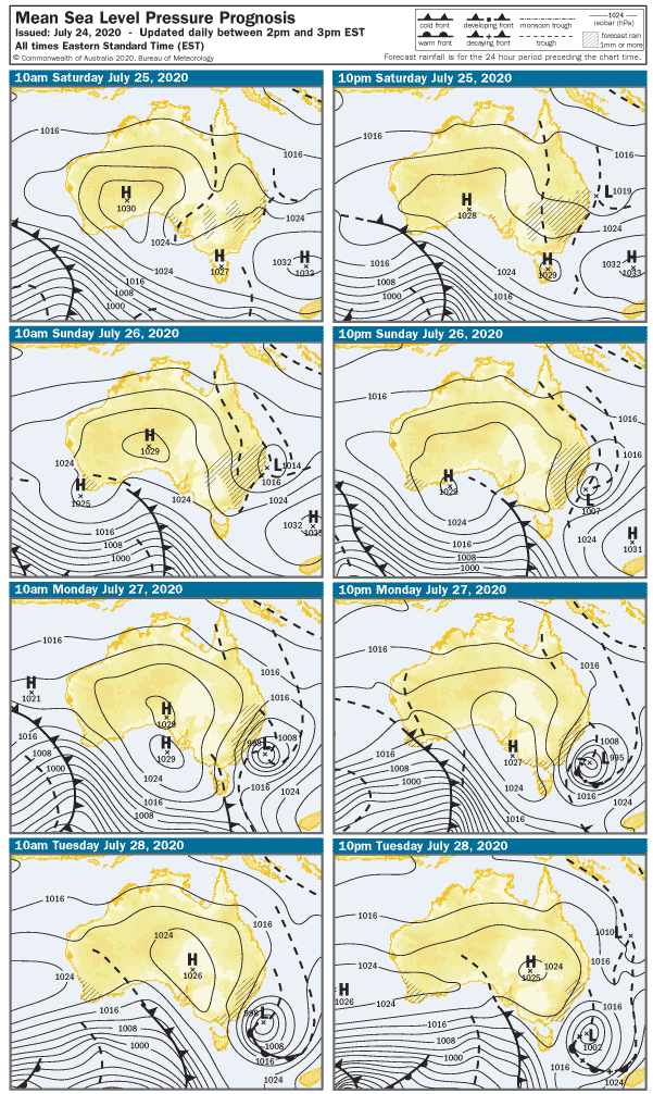
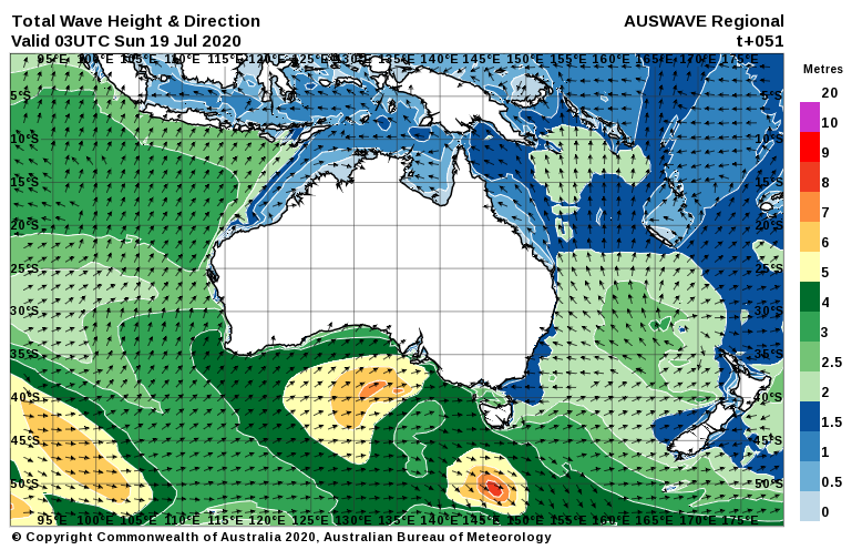
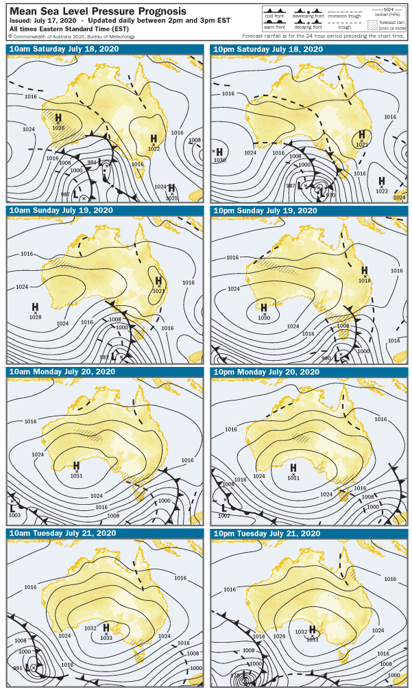
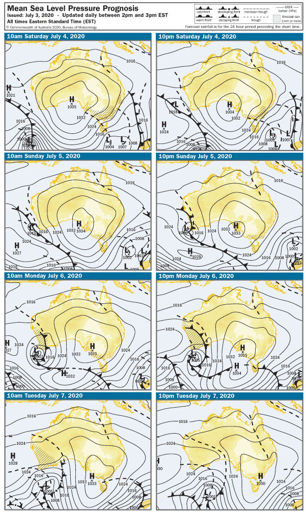
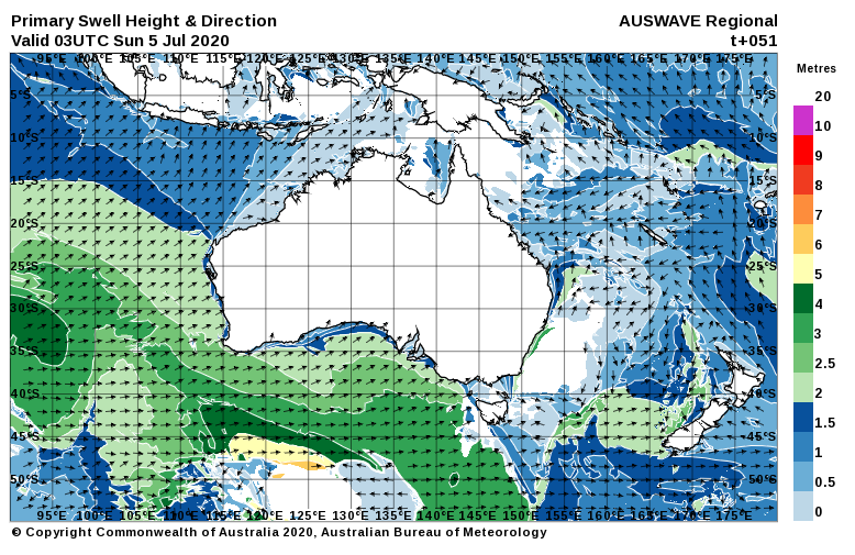
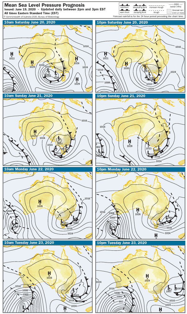
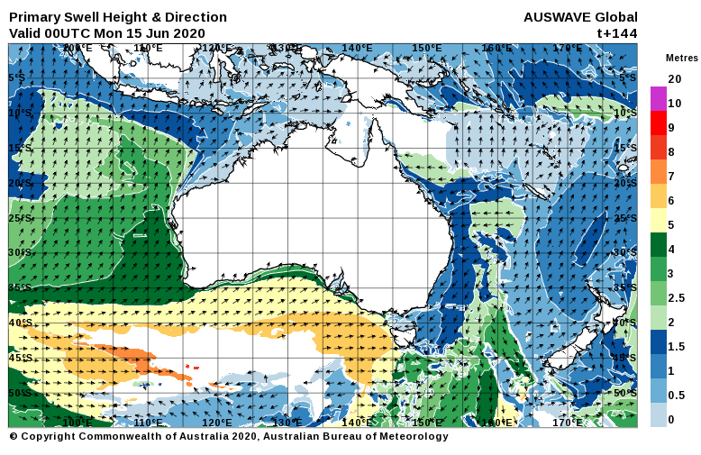
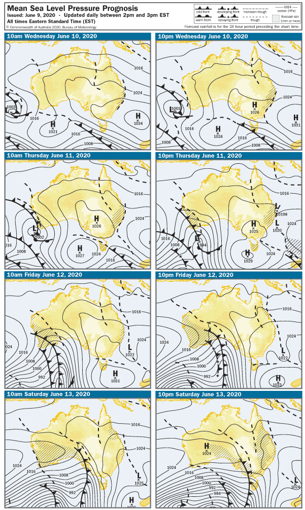
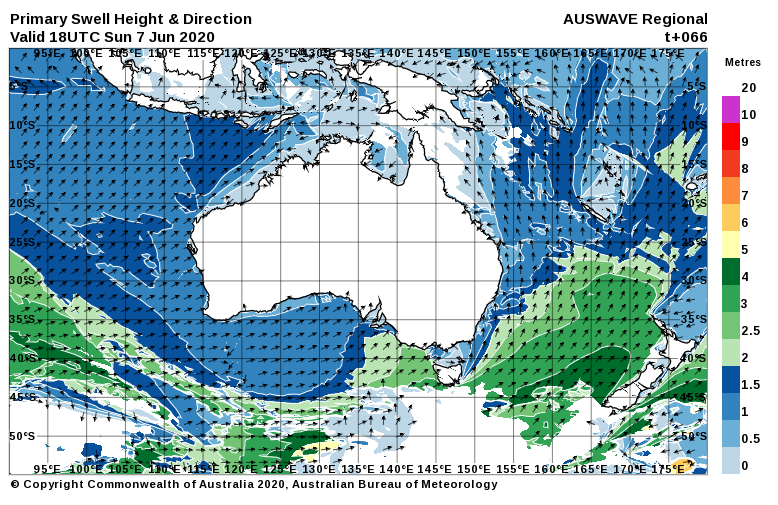
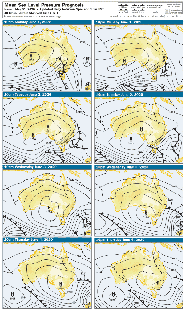
Another big HIGH will drift into SA over the weekend, and that means more nice, fine weather… and very light winds.  Some new WSW swell is sneaking across the state as I type, and it looks like it’ll deliver fresh swell to west-facing breaks over at Yorks early tomorrow. It will even bring a few 1 – 2′ waves to the Mid Coast if we’re lucky.  The models indicate light E-NE winds so expect glassy conditions early tomorrow over the Fleurieu and Yorke Peninsulas. The swell won’t be perfectly aimed down South, but there should be glassy 2 – 3′ waves at Middleton early on Saturday with winds probably NE at 3 knots.

Light winds will roll into Sunday, winds will be a puff from the North early, tending light W-SW after lunch, and possibly SE by late arvo.  Surf on the Mid Coast will stay in the 1 – 2′ range, and the swell should lift by a foot or so down South to 3 – 4′ at Middleton. It’ll be as clean as it gets early Sunday. Yay.

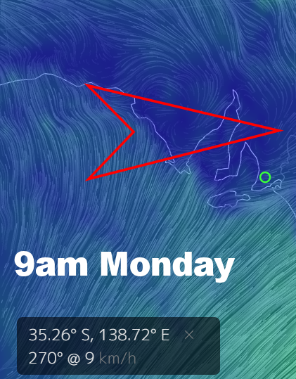
The breeze will kick around to the South as the front clips the lower half of SA early Monday, SSW at 5 knots early in the morning then SE at 10 – 12 knots by mid arvo. The light onshores will take the gloss off on the South Coast, but there may be a couple of opportunities on the Mid where a topped up WSW swell should deliver a few 2′ waves.

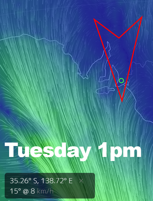
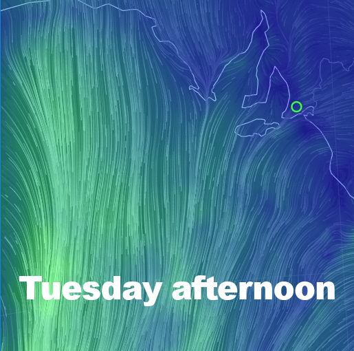
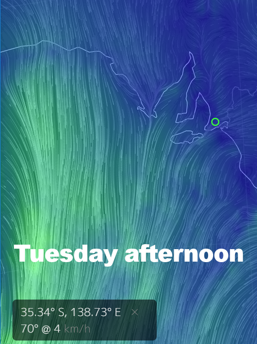
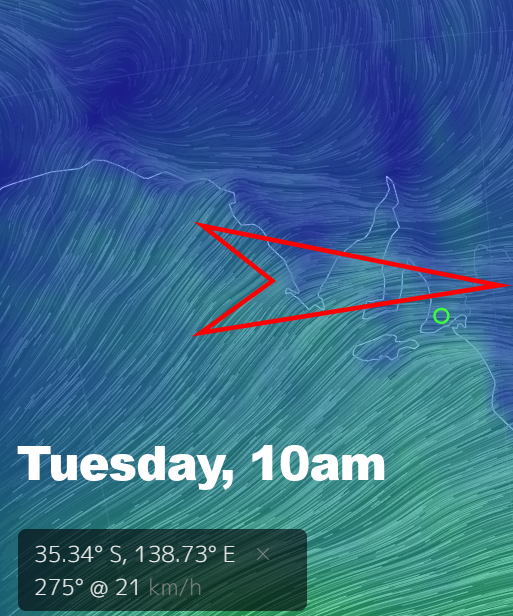
A light Northerly will resume on Tuesday, and the Mid Coast should remain in the 2′ range with light bumps from the wind. South looks great again, 3 – 4′ at Middleton, lined up and clean. The south coast of Innes NP looks clean and solid too, as do a few spots to the North you might know of.

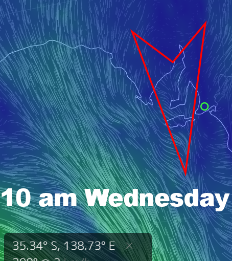
The wind will shift more to the West on Wednesday, 10 – 12 knots in the morning and 15 knots WSW after lunch. The Mid Coast will have bumpy 1 – 2′ waves, but a new WSW swell should lift wave heights after lunch. Middleton will be in the 3′ range and fairly clean in the morning, but the light cross-onshore may add bumps later.

A 20 knot sou-wester looks like arriving on Thursday, and wave heights should lift possibly to 2 – 3′ on the Mid Coast. Unfortunately, it will most likely be wind affected.  Middleton Bay will probably be your best bet down South, part-sheltered with surf in the 3′ range.

The breeze looks like it’ll tend more Southerly toward the end of the week, and the run of swell should continue with 2′ surf on the Mid Coast and 4 – 5′ waves on the South Coast… with onshore winds.

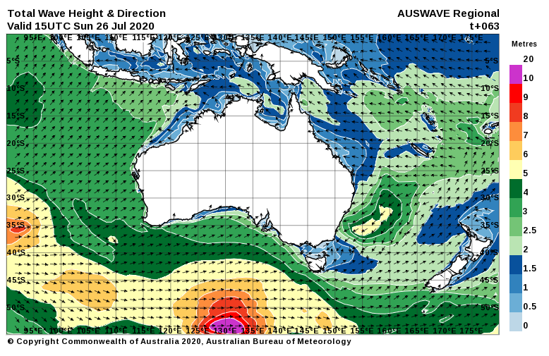
Another solid W-SW swell appears to be lining up late Thursday. More on that situation next week…

0

SA surf outlook Jul 17

Is anyone else still just waiting for winter 2020 to march across SA from west to east and hammer us with driving rain squalls and days of frigid darkness? No? So it’s just me then?

We’ve reached the end of yet another week of light wind and sunny weather, where the South Coast has been clean and pleasant pretty much every day. Even the Mid Coast managed a few days of surfable ( c’mon grant me some poetic license here, OK? )  waves with light winds, and needless to say, Yorkes and that other peninsula further west have been delightful all week.

Here’s the synoptic chart for the next few days. Notice anything? No… you don’t… because it actually looks almost identical to the chart from the last forecast. And maybe it is… and maybe I just changed all the dates… who can say?

The approaching trough will swing winds Northerly overnight tonight and early the breeze will be up around 15 knots. The South Coast will be your best bet on Saturday, but exposed stretches may become blown out mid-morning. Wave heights look in the 2′ range at Middleton, maybe a smirch bigger down toward Goolwa. The Mid Coast will be bumpy and 1′ all day.

The breeze will have more west in it early on Sunday, probably up around 22 knots at sunrise. The cross-shore winds will again blow out open beaches on the South Coast, surf will probably be 2′ at Middleton but it should  build after lunch.  A late paddle in the bay at Middleton is a possibility. The westerly swell will produce semi-stormy waves 2′ on the Mid Coast in the morning, but it should build to 3′ after lunch as the tide pushes in. Part sheltered spots may be worth a look, but grommies will probably be frothing over head-high onshore Seaford.

West-facing breaks over at Yorkes will be wind affected all weekend, but the more exposed breaks along the South Coast of Innes NP should be picking up plenty of swell – just a bit blown out.

The wind should all but drop out overnight on Sunday, leaving a very light westerly early on Monday.  The new swell should lift wave heights into the 4′ Middleton range and it’ll be reasonably clean in the morning.  It’s hard to say if the breaks between Victor and Port Elliot will get going, but it’ll be worth swinging by for a look. The wind will swing more to the SW after lunch, but it looks like it’ll hardly top 10 knots all day. There should be a few lumpy 2′ waves leftover on the Mid Coast too.

The wind will become very light mid-week as a large HIGH moves over Adelaide. There’ll be no wind early on Tuesday, and much of the Fleurieu and Yorkes should be glassy – possibly for much of the day. The Mid Coast should manage a few 1 – 2′ waves while the tide co-operates, and the South Coast will be back around 2 – 3′ at Middleton.

Wednesday might see a hint of North in the wind before it swings light Easterly and settles in for the rest of the day. The Mid Coast will be glassy again but probably smaller than the day before – around 1′. The East in the wind might add a few wobbles on the South Coast where waves are looking in the 1 – 2′ range at Middleton.

A light Northerly will follow on Thursday, and it doesn’t look much over 5 knots all day. A new WSW swell should lift size on the Mid Coast back to 1 – 2′, and it’ll probably be glassy all day. Middleton is looking around the 2′ mark, and the whole South Coast should be as clean as a whistle all day.

Most of Yorkes will be good mid-week.

The Northerly looks like it’ll gain strength on Friday ahead of another front, but let’s see how that’s panning out mid-next week. There’s also something large brewing out in the Indian Ocean heading into next weekend. Hope to have more news on that in a  few days time…

0

SA surf outlook Jul 10

Bit of a mixed bag coming our way this weekend, but the TL:DR is… go South early Saturday or miss out.

This week has been dominated by light wind and mild weather, but not a whole lot in the swell department. The week ahead is looking slightly better, but the uncertainty is larger than the last few weeks.

Let’s cut to the chase and say that if you want to surf the South Coast this weekend, you’ll need to hit it Saturday morning. The swell won’t be pumping but the great run of light offshore winds and clean conditions we’ve seen for the better part of the last week will prevail. Surf is looking around 2′ at Middleton, and it’ll probably be clean up until early arvo. The wind will swing West, then quickly go to an onshore Southerly after lunch. It won’t be all that strong, but it will be enough to take the shine off. The Mid Coast might be 1 – 2′ early Saturday but the N-NW wind will add bumps. Keep an eye on it… there looks like a few hours of light / variable winds through the middle of the day. Might even work with the incoming tide. Hell… it’s a Long shot…

Southerly winds will settle in on Sunday, and the South Coast will be onshore and bumpy.  The breeze will only be 12 knots by the looks, and surf will be bumpy and probably only 1′.  Wave heights on the Mid Coast will ease overnight on Saturday, leaving 1′ waves on Sunday. SSE winds at 15 knots look like adding bumps after lunch.

The Mid Coast will be nice and clean early on Monday with light ESE winds in the morning, but surf will probably only be around 1′. West facing breaks over at Yorkes will be bigger, also nice and clean all day. Surf should lift to 2′ or so on the South Coast, but with 10 knot SE winds, it won’t be special.

A new WSW swell should lift the Mid to around 1 – 2′ on Tuesday morning and very light ENE winds should keep it clean all day. West facing breaks over at Yorkes look great on Tuesday.  The swell should lift after lunch on the South coast and it’ll be glassy most of the day. 2′ at Middleton with a few bigger sets by late arvo.

Wednesday will see the start of a pre-frontal trend, the weather will be fine with North winds picking up during the day. The Mid Coast should maintain a WSW swell and waves in the 1 – 2′ range, but the wind will keep it bumpy from sunrise to sunset. It’ll be clean on the South Coast, but offshores my blow it out after lunch at 20  -25 knots. Surf should be in the 1 – 2′ range at Middleton, slightly more size around at Waits.

Thursday should open to a new WSW swell and 2′ waves on the Mid Coast, but a 20 knot plus NW wind looks like adding plenty of bumps. The swell should lift wave heights to 3′ on at Middleton, but it’ll probably be blown out most of the day.  The wind will probably swing to the West sometime between 10am and 4pm, with possible gusts over 25 knots.

A fresh W-SW airstream looks likely for Friday as a cold front moves through Southoz, the Mid Coast will probably be around 2′ but if there’s a stormy and the onshore gets up it’ll get bigger and messier.  Surf will probably be in the 3′ range at Middleton and cross-onshore, so the good ol’ Bay might be the wave of last resort.

A new WSW swell is lining up for next weekend, so stay tuned for an update toward the end of the week.


0

SA surf outlook Jul 3

Last weekend was a little slice of winter bliss, wasn’t it?

The South Coast was in the near-perfect size range with light offshore winds both days, and the weather was great. Even the fickle Mid Coast scored some clean, fun waves early on Saturday, and better still… the joint was practically deserted. Yorkes had very little wind and waves all over the place over the weekend, and most likely, so did the West Coast and KI.

This weekend doesn’t look nearly as good, sadly.

A large WSW-SW swell peaked on Thursday, and it’s on the way down as we head into the weekend. The wind is also easing off, but as I type it’s started raining again. Again.

Early on Saturday the breeze will be back to around 10 knots from the WSW, leaving a few lumps behind along West and South-facing coasts. The South Coast is looking semi-clean early with winds probably light from the West, but by early arvo it’ll turn onshore and bumpy. Wave heights will be back to around 2′ at Middelton, the Mid Coast will have leftover 1 – 2′ waves. 15 knot SSW winds will add bumps everywhere after lunch, by the looks.

The wind will tend more Southerly early on Sunday, probably only 5 – 7 knots all day. Surf will be bumpy with the light onshore wind on the South Coast, and waves will probably only be 1 – 2′ at Middleton. The Mid Coast will only be 1′ early, but after lunch a new WSW swell might lift wave heights by a foot or so. There’s a chance the wind will have a bit of East in it after 4pm, might clean it up a bit for a late one.

As a large HIGH moves west across Southoz the weather will become sunny and warmer ( by “warmer” I mean less colder ), and early on Monday a light land breeze will bring glassy ( and chilly ) conditions. The Mid Coast might manage a few glassy 1 – 2′ waves early, down South should be in the 2 – 3′ range but possibly a bit lumpy / glassy thanks to the East in the wind.

The wind will remain light on Tuesday, tending ENE then more NE later, and not getting much above 5 knots all day. The Fleurieu and Yorkes look glassy for the better part of the day, the Mid Coast will probably only have surf around 1′ though. Middleton will be closer to 1 – 2′, and clean most of the day. West facing breaks over at Yorkes won’t exactly be huge, but nice and clean all day.

Off the back of the HIGH winds will start to swing Northerly on Wednesday and Thursday. The Mid Coast will only be around 0.5 – 1′ on Wednesday, and Middleton isn’t looking a whole lot bigger. Winds should be NNW at 10 – 15 knots.

A Nor-wester will pick up early Thursday and it’s looking 20 knots plus not long after sunrise. The Mid Coast will be bumpy and only 1′, but the swell looks like it’ll lift after lunch. Middleton is also looking small early at around 1′, building 1 – 2′ after lunch.

A SW change looks like arriving around the end of the week, but timing is a bit hard to call at this stage. Mid-week looks OK for Victor, early Saturday might be worth a punt also.

0

SA surf outlook June 26

I’m giving last week’s forecast a C+. It probably would have been a “C”  if not for the outrageously optimistic call of a WSW swell 5 days out that actually played out, producing a few rare 2′ wave on the Mid Coast and fun, glassy head high waves over at Yorkes today. The swell down South was actually bigger than expected early last week, and there was even a nice window for a few hours on Saturday that I completely missed. Sure… it was small… but it wasn’t quite the write off  I’d called. Let’s hope I can rescue last week’s minor pedestrian collision of a surf forecast with some good news for the days ahead.

The weekend looks really nice.

Winds will have a poof of North in them on Saturday  and Sunday, but it probably won’t top 7 knots on either day.

Tomorrow on Saturday a fading SW swell should still serve up some 1′ waves on Mid Coast reefs, and it’ll be glassy early.  The South Coast will also be clean and glassy early, if not all day. It’s a two-foot Middleton kinda scenario, but quality will be about as good as it gets, and who knows… you may even score the odd  2.5′ set and have to get your hair wet duck diving.

Sunday will be smaller everywhere as the swell fades, but it’ll be clean again with North winds under 10 knots.

The breeze will pick up for the start of the working week, tending NNE at 15 knots early Monday. The swell will drop and Middleton will be back to around 1′, and the Mid Coast will probably be only around 0.5′ and bumpy. A new WSW swell might lift The Mid to 1′ after lunch.

NW winds will pick up to around 25 knots early on Tuesday. The Mid Coast with be bumpy all day, but wave heights should build from 2′ in the morning to maybe 3′ after lunch. The swell direction looks a bit off for the South Coast, and Middleton will probably only;y be around 1′ in the morning, building to 2′ later in the day.

NNW winds look in the 17 knot range early on Wednesday, and by early arvo NW winds may be gusting 27 knots. A great WSW swell on the Mid Coast will really cop it from the wind, but surf may be up to 3′ through the middle part of the day. Anywhere with windmills or anyone with a sail will be loving it.

NW-W winds look closer to 30 knots on Thursday, and a solid WSW swell might even bring some bumpy 3 – 4′ sets to the Mid Coast. The swell should also lift on the South Coast with Middleton in the 3 – 4′ range. Almost everywhere on the South Coast will be blown to bits by the wind.

At this stage it looks like a cold front will swing winds strong WSW into Friday, possibly delivering a stormy. The Mid Coast will be in the 3′ range but it looks like the swell will peak late thursday and ease into Friday.  Down South will be bigger but effected by strong cross-onshores, with Middleton possibly in the 4 – 5′ range.

Conditions should settle down heading into next weekend. For now, enjoy a nice, calm early winter Saturday and Sunday.

0

SA surf outlook June 19

Geez, I have heard a few whackyballz surf predictions for this weekend, so let me set the record straight and tell you… it’s gonna suck.

Most of the last week has been under the influence of a perfect early winter weather pattern. We got light winds, we got sunshine, we got a nice glassy day on the Mid and one clean, pumping swell down South. Take a moment to bask in that memory.

A LOW will cross Adelaide tonight, and the wind will be back to a moderate Nor-wester on Saturday morning. Ordinarily, that’d be good news for a winter Saturday on the South Coast, except for one tiny problem…. swell. When I say tiny…  glorious 1′ Middleton awaits you tomorrow morning, and Waits isn’t looking much bigger. The wind will make the Mid Coast bumpy, and waves will also only be 1′.

I’d like to tell you Sunday will be better. It won’t.

Strong Westerlies will arrive before dawn  with gusts to 30 knots. The Mid Coast will be choppy and onshore, and the wind might whip up some 2′ junk by morning bakery pie time.  A very westerly swell will roll right by the South Coast, but Middleton might build from 1′ early to maybe 1 – 2′ later in the day.  What a shame the wind will be dead onshore from the South by then at 15 knots. Choppy 1 – 2′ dross looks likely.

The wind will tend more Westerly for the start of the new week, and so will the swell direction. It may be clean on Monday morning on the South Coast, but surf at Middleton looks like it will remain in the 1′ range.  The Mid Coast will be messy and onshore, and also only around 1′.

On Tuesday a Southerly airstream will kick in, 7 knots in the morning and maybe 7 – 10 knots SSE after 3pm.  A new WSW swell should lift wave heights on the Mid Coast to 1 – 2′, but it will probably cop a few bumps from the wind. The South Coast’s dreadful run looks like it will continue, with 1′ slops at Middleton.

Like last week, Wednesday is a sort of in-between day.

The wind will be very light from the North early and the Fleurieu will be glassy – but small. The Mid Coast will only have waves around 1′. and Middleton probably won’t be any bigger. Waits or Parson’s will be your best bet.

Thursday will see a return to a more wintry Nor-wester at around 15 knots by sunrise. Surf will be bumpy and around 1′ on the Mid Coast, but it should build to 2′ after lunch ( and remain bumpy ). The swell will be very West again, so Middleton is looking in the 1′ range again, but really clean. Once again, small, clean waves at Waitpinga are probably your best bet.

Looking into the crystal ball, another WSW swell and cold fronts are lining up toward the end of the week, but that’s a long way off. Options will be limited over the next week, so hopefully you followed the absolutely excellent and completely flawless advice in last week’s forecast, and scored.  Don’t forget to click those ads in appreciation. 😀

0

SA surf outlook June 14

How are your tanks looking?

It’s been a wet, windy old weekend in SA and surf options have been limited to say the least – but the wind-powered crew have been loving it. There was a nice run of light wind and offshores on the South Coast last week, but the breeze looks like easing off on only one day this week.

The synoptic chart is looking pretty cool again, with a huge trough extending from Cape York to the Southern end of New Zealand and three high topical high pressure systems over the continent. But of more interest is a new, strong Westerly swell that has already hit the west coast and will close in on Adelaide overnight.

The week will kick off with 22 knot WNW winds, and a building swell along west-facing coastlines. Unfortunately, anywhere copping this solid swell head-on will be onshore and messy. There is, however, a chance that a few sneaky favourites will get a run on Monday, with the swell big enough to wrap into a few of them.  On the South Coast the swell will be bigger tomorrow ( e.g waves will be bigger than one foot at Middleton! ), but anywhere exposed will be blown out by fresh cross-offshore winds. The swell will build all day, and there’s a chance part sheltered spots will get a look-in late arvo. The Mid Coast will quite probably get to 3’… possibly even bigger at some spots.

The breeze will be more WSW on Tuesday, and the swell will be past its peak. That being said, there will still be plenty of swell across the Yorke and Fleurieu peninsulas. The Mid Coast may be 2 – 3′ in the morning, but it’ll still be messy with onshore winds in the 15 – 20 knot range. Middleton will be up to 5′ or bigger, and part sheltered spots will be worth a looky. The swell does have a lot of west in it, and that will put a cap on size. A few lesser known spots over at Yorkes might be OK on Tuesday,  but the exposed tip of the peninsula will be very big and messy.

Wednesday is a little bubble of bliss.

The wind will drop out overnight, and by early morning a Nor-easter at 2 knots should provide glassy conditions over the Fluerieu and Yorke Peninsulas. Light winds will persist all day, and with a bit of North in it the South Coast is looking great. There even should be a few 1 – 2′ waves left on the Mid Coast, and with light winds expected all day it’ll stay clean and fun. Swell should still be up on the South Coast with Goolwa possibly in the 6′ range and glassy first thing. The Port Elliot – Victor stretch could be very good Wednesday morning, despite a less-than-perfect swell direction. All of Yorkes looks great, all day.

The wind will kick back to the North on Thursday, and will probably be over 15 knots not long after the sun comes up. The Mid Coast will be bumpy with leftover 1 – 2′ waves, but it’ll be clean on the South Coast with an easing SW swell.  Middleton looks in the 3′ range early, but it’ll probably drop to an inconsistent 1 – 2′ after lunch.

NW winds will be slightly stronger on Friday at 20 knots, shifting fresh Westerly after lunch at 25 knots or more. A new WSW swell will push in from late morning onward, lifting waves heights along west-facing coastlines. The Mid Coast may see some 2 – 3′ waves late arvo, but it’ll be messy and onshore. The South Coast won’t do as well with so much west in the swell, Middleton will probably only be 1′ early and blown out.

A cold front will bring fresh WSW winds as we head into the weekend and stormy waves to the Mid Coast. It won’t be a massive stormy with winds in the 25 knot range, and surf maybe getting up to 3′ between South Port and Moana. The wind will be cross-onshore on the South Coast and it’ll be blown out on Saturday, with Middleton around 2 – 3′ later.

The SW wind will moderate into Sunday but at 20 knots it’s still looking messy at anywhere exposed. The Mid Coast should still be 2′ or a foot bigger in the morning, with Middleton maybe 3′ but wind effected. This situation may well change as weather patterns evolve later in the week.

Watch this space for an update…


0

SA surf outlook June 9

I gotta admit… I don’t mind June in Southoz.

It’s cold for sure, but at least it’s not downright nasty. There are days of glorious sunshine and light winds, and a steady stream of Indian Ocean cold fronts regularly top up the swell bucket.

It’s pleasing to see that last week’s forecast pretty much went to plan,  delivering clean waves well within the predicted windows. South was surprisingly solid on her majesty’s faux birthday, and clean all day with light offshore winds and only a minor Easterly wobble.

We have a couple more days of lovely, light winds, but the billion dollar question is,  will there be any swell?

This week’s charts are really interesting from a Metnerd™  perspective. A cold front will slip south of Adelaide on Wednesday, swinging winds NW and then South late in the day. And will you take a look at that complex low and warm front on Thursday! Cool, huh?! In any case, 5 knots is about as strong as the wind will probably get, and a new SW swell will sneak in during the day. West facing breaks over at Yorkes might get it a bit earlier, but even the Mid Coast might see a few 1′ waves by late arvo. The swell will pick up on the South Coast but it’ll start off small with waves around 1 – 2′ at Middleton.

The swell should lift the Mid Coast to 1 – 2′ on Thursday, and it should stay clean with light NE winds tending East at 2 knots after lunch. West facing breaks over at Yorks look fun Thursday arvo. Surf at Middleton should pick up to around 3′, and have similar conditions to the holiday Monday.

The winter Northerlies will return early on Friday, and a 15 – 17 knot offshore breeze will settle in on the South Coast all day. Middleton should hold around 3′ in the morning, but the swell will probably wind down after lunch. The Mid Coast will be bumpy with the Northerlies, but surf should remain in the 1 – 2′ range. Breaks along the South Coast of Sothern YP look pretty good on Friday.

The weekend looks like it’ll open with a fresh Northerly ahead of a gusty Westerly change around 2pm. The Mid Coast will be bumpy with surf around 1′ on Saturday, and Middleton will probably only have surf around 1′. It’s a bit of an in-between day to be honest, so unless you have some sort of sail or kite, forget it.

The late change on Saturday will leave westerly winds behind it, so early on Sunday the Mid Coast will be onshore and messy with 15 knot West winds and 1 – 2′ waves. It’ll be cleaner on the South Coast but Middleton will be small in the morning – probably only 1′. The wind will pick up after lunch and tend more WNW.

The Mid Coast will be near flat on Sunday, and Middleton will only be 1 – 2′ with West winds at 15 knots shifting WNW at 22 knots after lunch. A new WSW swell will lift wave heights along west-facing coasts late on Sunday.

A new WSW swell should arrive for the start of the working week, and it looks like stormy 3′ surf on the Mid Cost on Monday morning. Winds will be onshore from the West at 25 knots. Middleton should pick up to around 2 – 3′ for the start of the week, winds are looking like 25 knots from the West so Middleton Bay may be the go.

The breeze should be more SW by Tuesday, at this stage around 25 knots. The Mid Coast will be onshore and messy at 2′, Middleton should be around 3′ and a bit blown out.

More swell later nest week, but we’ll see how that pans out Monday – Tuesday-ish.


0

SA surf outlook June 5

Welcome to winter 2020, I hope you all enjoyed a little FREE sample this morning.  Many locations around the state were barely above freezing at 0530, and on the Fleurieu anyone without the luxury of a garage was scraping ice off the car windshield before heading off to work.

The TL:DR for the long weekend is light winds, small swell and lumps on the South Coast until a small window on Monday afternoon. Let’s drill down.

As we head into the penultimate long weekend of the year, a large HIGH pressure system will drift Eastward over SA.  A dwindling  WSW swell will get a minor top up overnight, but it probably won’t be enough to deliver much more than 1′ waves to the Mid Coast early on Saturday. Light East winds will mean it’s clean and glassy again, but the East in the wind will maintain lumps on the South Coast all day. Middleton will be in the 2 – 3′ range, probably smaller after lunch.

The wind will pick up a bit on Sunday tending SE at 10  -12 knots early then ESE at similar strength after lunch. The Mid Coast is looking nice and clean, but small – inconsistent 0.5 – 1′ waves are likely. Down South, the cross-onshore winds will add lumps again, and Middleton will have surf in the 2 – 3′ range. Parson’s is probably your best bet. West facing breaks over at Yorkes will be clean over most of the weekend, but it’s looking like a 1 – 2′ Pondie scenario. More exposed spots will be bigger, and less busy, of course…

The holiday Monday should open to very light ENE winds, tending light NE from early arvo onward.  The Mid Coast will be clean but only shin-high – your best bet is to head for the South Coast. The weather should be good and a light Nor-easter will iron out a few lumps after lunch. A minor swell top-up might get dear old Middleton back into the 3′ range wavewise, and it’ll be bigger West of Victor if you’re fitter, and cooler.

Heading back to the office on Tuesday winds will be perfect on the South Coast , tending NE at 7 – 10 knots then variable after lunch. The swell will be smaller but Middleton should still manage a few fun two footers, with more size and glassy conditions around at Waits and Parson’s.

The light winds and fine weather look set to continue into Wednesday, and the Mid Coast should see a few 1′ sets thanks to a lift in SW swell. The same swell will build during the day on the South Coast, with Middleton around 2′ early but building 3 – 4′ by late arvo. Yorkes looks good.

The Mid Coast will be slightly bigger Thursday morning but at this stage, 15 knot Northerlies and bumps are expected to arrive not long after sunrise. That could all change in the next few days, of course. Middleton will be clean and possibly up around the 4′ mark, making Thursday probably the best day in the forecast period.

Looking into the crystal ball, Northerlies will probably pick up on Friday ahead of a cold front heading into next weekend.

More on that situation early next week…

0

SA surf outlook May 31

Well, here we are on winter’s doostep so I guess it’s no surprise it feels sorta… wintry?  This weather will take a couple of days to blow through, but later this week we should be back to finer conditions and light winds.

Last week’s forecast panned out pretty well with a few good days on the South Coast and the predicted WSW lighting un the reefs breaks on the Mid Coast and over at Yorkes Wednesday / Thursday. The wind was a bit of a dud though, tending more NW and stronger than expected at the height of the swell. To those who picked the little windows of opportunity and didn’t have to be somewhere else significantly less fun when they arose,  bravo.

Winter 2020 will open with gusty WSW winds and rain, and stormy conditions in the Gulf of St. Vincent. The Mid Coast will be 3 – 4′ on Monday but most of the usual suspects will be off-limits. Part sheltered spots will be the go and yes, that probably includes Adelaide’s worst kept secret spot. Take a ticket, and wait patiently. The less-than-ideal swell direction for the South Coast will leave Middleton around 2′, maybe 3′ along the Day St. stretch with strong cross-onshore winds. It probably won’t be big enough for sheltered spots.

The wind will ease and stay out of the West early Tuesday, leaving wind effected 2 – 3′ waves on the Mid Coast. The South Coast could be OK early – mid morning, and there’s even a slim chance of a bit of North in the wind at 17 knots.  Middleton is looking in the 3′ range so the Bay is a reasonably good chance for clean-ish waves.

Late Tuesday’s SW wind will swing dead onshore overnight, and early on Wednesday a 10 knot Southerly will create messy conditions on the South Coast. It’s a shame, because a new SW swell will fill in during the day, and the Middleton – Goolwa stretch may get back up around 6′ after lunch.  The wind will be rubbish for sheltered spots, unfortunately. Meanwhile, west-facing breaks will start to improve as winds tend more offshore from the SE at 10 knots later in the day.  The Mid Coast should have some 2′ waves on the incoming tide, and it is looking cleaner after lunch at this stage. West facing breaks over at Yorkes also look good after lunch on Wednesday.

As a large HIGH moves over Adelaide winds will become very light early on Thursday, with a light land breeze and glassy conditions on the Mid Coast. Surf should still remain in the 1 – 2′ range, after lunch the incoming tide may give it a push mid arvo. The large fading swell will leave solid waves on the South Coast early Thursday, probably glassy at dawn but lumpy from the onshores the day before. West facing breaks over at Yorkes look pretty good Wednesday – Thursday.

The wind will tend more Northerly toward the end of the week and heading into the weekend. Friday will kick off with a light Nor-wester, picking up 10 – 15 knots mid-morning – possibly dropping out again after lunch. The breeze will gove the Mid Coast the wobbles but some lingering swell should leave a few 1 – 2′ waves behind. The smaller swell will leave Middleton around 1 – 2′, but it’s looking  clean as a whistle all day.  The swell will stick around over at Yorkes, the early might be OK.

The weather is lining up very much like the weekend before, with a front moving into SA for the start of the long weekend.  Saturday is looking like a freshening NW wind ahead of a gusty WSW change later in the day. Sunday looks stormy with strong onshore WSW winds, similar to Monday. The Mid Coast will be wind affected and surf will be in the 1’+ range, and surf will probably be small and blown out on the South Coast.

I’ll sneak in a new forecast before the long weekend, so hopefully there’s some good news there.

0